

Sorsogon, in the Bicol Peninsula, is at the southeastern
tip of Luzon Island. It is bounded on the north by
Albay (where Mayon Volcano is) and Albay Gulf, on the east by the Pacific
Ocean, on the west by Burias and Ticao Passes, and on
the south by the Samar Sea and
San Bernardino Strait.
A 10-day trip to Bicol's southern provinces of Sorsogon and Albay would be ideal. If you hope to cover the four provinces of Bicol (the other two provinces are the islands of Catanduanes in the Pacific side and Masbate in the Visayas side), you might end up disappointed. You'll be lucky to do two in 10 days.
The "new diversion road", called Quirino Highway, bypasses much of Quezon National Park, and saves you two hours of travel time as you wonÕt have to go through Daet, the capital of Camarines Norte.
The old road that goes through the park is refered to as "eme-eme" by the locals because "it is like driving on the letter m."
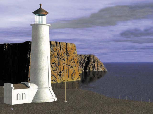
In Sorsogon, one of the best inns is Fernandos Hotel. David Duran, whose family owns the hotel, is a gracious host and offers guides on how to go around Sorsogon in two to three days. When in town, don't miss touring around Bulusan Volcano. The main landmark of Sorsogon City is the Cathedral of Sts Peter and Paul. The back side offer a good view of Sorsogon Bay.
In Prieto Diaz, interesting sites include
Nagsuroc and Pinanaan Caves, and Toten Beach where you
get a good view of Mayon Volcano and Rapu-Rapu Island.
Gubat town is known for its expansive picturesque fine cream sand
Rizal Beach that many liken to an undeveloped Waikiki. If you like chicharon, JunJun's snackyard, beside Gubat town
market, is known for its excellent chicharon.
Centuries-old Barcelona Church and ruins are in the
neighboring town. From Barcelona, drive to Bulusan
Volcano National Park. The idyllic Bulusan Lake is
2,000 ft above sea level.
A 2.9 km cemented trail takes you around the lush perimiter of the lake. For trekking junkies, Mt Bulusan is a 2-day
climb (contact PENRO, Sorsogon, tel. (6356) 211-1461
or 211-1205).
Then there's the recently remodelled Irosin Church, which sits on top of a hill in the farming town. It offers a nice view of Bulusan Volcano. In Juban, admire nice the old houses.
A trip to Matnog, southernmost town on Luzon, offers a marvelous scenery along the way--rice fields and gentle green volcanoes. Before Matnog is Bulan, departure point for ferries to Masbate and Ticao Islands. Also in Bulan is a centuries-old
Spanish church. Matnog is the departure point for the
ferry to Alen, Samar, a sign at the port reads "you are now
leaving the island of Luzon."
This is one of the cleanest ports I have seen--the water is clear and not murky and boys dive off the pier to retrieve coins that people throw in. Nearby are Tiklin and Calintaan
islands. Tiklin has a pristine white sand beach: be
careful as currents can get strong (banca rental to
Tiklin is P500). There is snorkeling off cream sand
Subic Beach on Calintaan. In the nearby forest is
a cave inhabited by bats.
Also visit the cream sand beaches of Sta Magdalena. Villa Veronica is a day resort along a narrow beach. Take a refreshing dip in the clear waters or rest under one of the picnic huts.
ThereÕs the very pretty Olango Beach in
barangay San Rafael. There is good swimming in the
middle (where it is sandy beneath the water) and
snorkeling on the outer fringes (by the reefs). The
sea is an inviting clear aquamarine and tall coconut
trees fringe the shore.
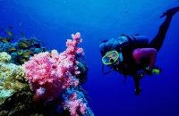
Bacon is also a good place to check out. Off Tolongapo Beach is one of the best dive spots of Sorsogon. Several simple
resorts line the beach. Also near Bacon are the Bato
Limestone Caves, where ancient artifacts were
excavated in 1956.
These are just a tiny portion of the many sites
this province posseses.
The land: Mountains sprawl along the northeastern part
of the province.
The tallest peak is Mount Bulusan, an active volcano
1560 above the sea level, Lake Bulusan lies on its
slopes.
The major rivers are the Cawayan River in Sorsogon
town and the Putiao River in Pilar.
The capital town lies on the slender rock of land that
joins the province«s two parts separated by Sorosogon
Bay. Except for landlocked Irosin, all the towns lie
along the coast.
The eastern half of the province has na dry seasons
but with very pronounced maximum rain period from
November to January, while the western half has
rainfall more or less evenly distributed throughout
the year.
Sorsogon lies at the hearth of the typhoon belt.
Sorsogon was established as a province on October 17,
1894. Bicol is the predominant dialect but
because it is a gateway to the Visayas, their version
is a unique mixture of Visayan and Bicol dialects.
The province has a fertile soil due to past
volcanic eruptions and yearround rainfall make
Sorsogon a major producer of abaca. It is said the
province produces the best hemp in all of Bicol.
Other crops widely grown are coconut and rice.
The province also has a significant fishing industry
as it is surrounded by rich fishing grounds.
Raw materials abound for cottage industries.
Deposits of sulphur, kaolin, limestone and coal are
largely untapped. Sorsogon City is only
59 kilometers away from the airport. Buses come from the south on the way to
Manila, and from Manila to the south go through
the province.
 Although renowned for its majestic, almost perfectly
conical Mayon Volcano, the Bicol region has so much
more to offer.
Although renowned for its majestic, almost perfectly
conical Mayon Volcano, the Bicol region has so much
more to offer.
 Around Rapu-Rapu are a few dive spots. To get to Rapu-Rapu Island, hire a banca from Prieto Diaz town
proper.
Around Rapu-Rapu are a few dive spots. To get to Rapu-Rapu Island, hire a banca from Prieto Diaz town
proper.
Natural Spring Resorts
Sorsogon is also known for its many natural spring
resorts. Around Bulusan are Paloktok, an inviting
spring-fed swimming pool, Masacrot known for its
consistency of mineral soda, and Mateo Hot and Cold
Springs in San Benon, Irosin. Other popular springs, Palhi and
Bucalbucal, are north of Sorsogon town proper.
Geographical Features
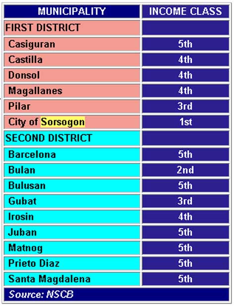
Capital: Sorsogon
Area: 2 141,4 sq km
Population: ca. 700 000
Cities: 1
Number of Towns: 15